|
The ILRS 2009 Fall Workshop was held in Metsovo Greece on September 14-19, 2009. The workshop was organized by the ILRS and the National Technical University of Athens, Greece (NTUA).
 |
The 2009 ILRS Technical Workshop (first/second/third circular) addressed a very timely issue: the tracking of
current and future GNSS constellations with SLR. The idea behind this workshop
was to bring together experts from the SLR and GNSS communities providing them
with a forum to discuss all aspects of the theme, focusing primarily on the science
benefits, while tackling also problems arising from the large number of GNSS clients
and the finite resources available to ILRS. In the opening lecture of the workshop,
Professor Emeritus of the National Technical University of Athens, George Veis, the
person to whom the workshop was dedicated on the occasion of his 80th birthday
and who is by most considered the father of satellite geodesy, offered an excellent
historical review of space geodesy, from its inception to present, including all
modern space techniques with many examples and some rare photographic records. |
This website provides access to the presentations and session summaries from the workshop. Furthermore, an executive summary and a full meeting report, (which includees the session summaries) are available. The presentations are organized by session:
| Registration and Opening |
| |
Opening remarks, Prof. (Emeritus) D. Balodimos, National Technical University of Athens |
| Opening lecture, Prof. (Emeritus) G. Veis, National Technical University of Athens |
| The Impact of SLR Tracking on GNSS Constellations Position Papers (E. Pavlis) |
| |
GPS, T. Springer |
GLONASS (current/future), V. Vasiliev, V. Glotov |
Galileo, T. Springer |
COMPASS, X. Wang |
QZSS, M. Sawabe, S. Nakamura |
Status of SLR and the ILRS, M. Pearlman |
 |
Zip file of all presentations in The Impact of SLR Tracking on GNSS Constellations session |
|
| Science from SLR and GNSS - A (D. Paradissis) |
| |
Processing large volume GPS data via Bernese V4.2 software, C. Mitsakaki, A. Marinou, X. Papanikolaou, K. Papazissi |
InSAR mapping of surface deformation on Lefkada island during 1992-2006 and its relation to seismic activity, A. Ganas, V. Koraka |
| Crustal Deformation from GPS measurements at the Ionian Sea: Preliminary Results, D. Anastasiou, D. Paradissis, A. Ganas, A. Marinou, K. Papazissi, G. Drakatos, K. Makropoulos |
| Science from SLR and GNSS - B (A. Ganas) |
| |
Accurate Geoid Undulation Determination along a 120 km Long Railway Traverse in Central Greece: Preliminary Results and Validation, V. Gikas, A. Androulaki, A. Bimis, V. Zacharis, K. Fragos |
| The Eastern Mediterranean Altimeter Calibration Network – eMACnet, E. C. Pavlis, K. Evans, P. Milas, B. A. Massinas, D. Paradissis |
| The ASI/CGS contribution to the ITRF maintenance: the ILRSA solution, C. Sciarretta, V. Luceri, G. Bianco |
| Contribution of Future SLR Networks to the Development of ITRF, E. C. Pavlis, M. Kuzmicz-Cieslak, P. Hinkey |
| The GPS-SLR bias: dynamics, attitude and current experiments, M. Ziebart, T. Springer |
|
| Science from SLR and GNSS - C (K. Katsampalos) |
| |
Apparent Geocenter Oscillations in GNSS Solutions Caused by the Ionospheric Effect of Second Order, K. Palamartchuk |
| Adaptive Likehood Estimator for Forecasting Ionospheric Component on Synthetic Aperture Radar Interferometry (InSAR) Technique, B. A. Massinas, N. Doulamis, D. Paradissis |
| A Tapped Delay Line Neural Network for Modeling Ionospheric Disturbances Behavior, A. Doulamis, B. A. Massinas, D. Paradissis |
| Advanced Signal Processing Techiques for Inverse Synthetic Aperture Radar (ISAR) Imaging, A. Karakassiliotis, G. Boultadakis, G. Kalognomos, B. A. Massinas, P. Frangos |
| Summary of recent and current research on ISAR Signal Processing at the NTUA, Greece, P. Frangos |
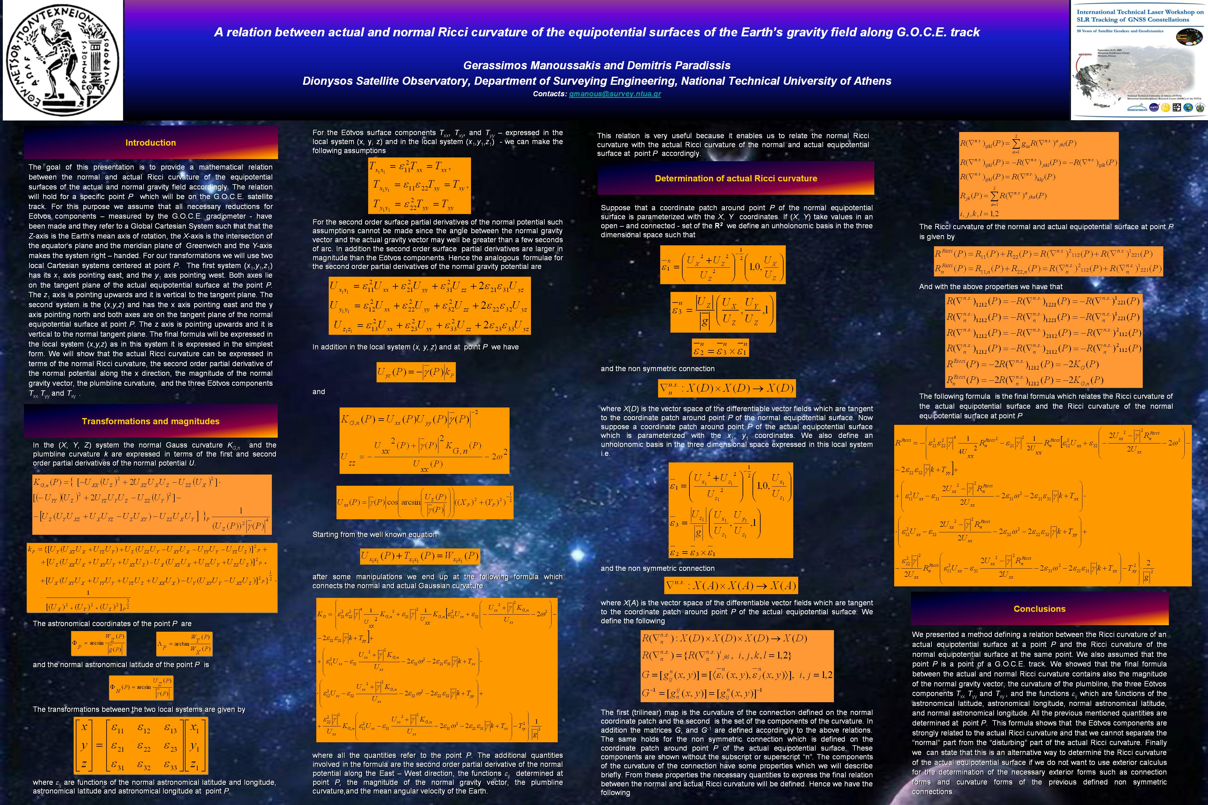
| A relation between actual and normal Ricci curvature of the equipotential surfaces of the Earth’s gravity field along GOCE track, G. Manoussakis and D. Paradissis |
Deformation of the southern Aegean from continuous Global Positioning System measurements Kirill Palamartchouk (poster), K. Palamartchouk, M. Floyd, P. England, B. Parsons, J.M. Nocquet, C. Raptakis, D. Paradissis, H. Billiris, J. Galanis |
| Science from SLR and GNSS - D (V. Gikas) |
| |
Hellenic Terrestrial Reference System 2007 (HTRS07): A regional realization of ETRS89 over Greece in support of HEPOS, K. Katsampalos, C. Kotsakis, M. Gianniou |
| Discussion (Datums) |
|
Zip file of all presentations in Science from SLR and GNSS sessions |
|
| Scientific impact of SLR tracking on GNSS Constellations (J. Ries) |
| |
Scientific impact of SLR tracking on GNSS Constellations Position Paper, E. Pavlis |
| SLR Tracking of GNSS Constellations, E. Pavlis, M. Kuzmicz-Cieslak, P. Hinkey |
| What is the benefit of tracking GNSS satellites with SLR?, D. Thaller, R. Dach, G. Beutler, M. Mareyen, B. Richter |
| An assessment of the value of SLR observations to GNSS, R. Govind |
| Collection and processing in TSNIMASH of GLONASS spacecraft ranging data obtained by Russian and global SLR network stations, V. D. Glotov, N. N. Parkhomenko |
| SLR Observations of COMPASS – G2, Y. Fumin, Z. Zhongping, C. Juping, C. Wanzhen, Z. Haifeng, W. Zhibo, M. Wendong |
| ESOC SLR Activities, T. A. Springer, C. Flohrer, M. Otten, D. Svehla, J. Dow |
| Two approaches to build time series of EOP from SLR data, F. Deleflie, D. Coulot, B. de Saint Jean, J.-M. Lemoine, P. Exertier, O. Laurain |
| Laser Ranging to GNSS & LPOD2005, J. Ries |
|
Zip file of all presentations in Scientific impact of SLR tracking on GNSS Constellations session |
|
| Operational Issues (M. Pearlman) |
| |
Operational issues Position Paper, G. Appleby |
| Scheduling lessons learned from Lunar Laser Ranging, R Ricklefs |
| Operational 'Best Practices' for the NASA laser systems, H Donovan |
| Possible strategy for laser tracking the future GPS constellation, S Wetzel |
| Potential Scheduling Applications to the Tracking of the GNSS Constellations, C Clarke |
| GOCE orbit predictions for SLR tracking, A. Jäggi, H. Bock, W. Gurtner, R. Floberghagen |
| Towards 2kHz new SLR system in Metsähovi, K. Arsov, A. Raja-Halli, J. Näränen, M.Poutanen |
| Routine kHz tracking at Changchun and Shanghai, Z Zhongping, Y Fumin, et al |
| Navigation of the RadioAstron Mission, R. M. Bebenin, Y. N. Ponomarev, V. A. Stepanyants |
|
Zip file of all presentations in Operational Issues session |
|
| Technology Challenges (G. Appleby) |
| |
Technology Challenges, M. Pearlman |
| Uncoated Cubes for GNSS Satellites, D. Arnold |
| Proposed Single Open Reflector for the GALILEO Mission, R. Neubert, J.Neubert, J. Munder, L. Grunwaldt |
| Target signature effects on laser ranging accuracy for the GIOVE satellites, T. Otsubo, P. Gibbs, G. M. Appleby |
| Relative signal strengths from SLR tracking of the different retroreflector targets onboard HEO satellites using the fullrate data set, M. Wilkinson, G. Appleby |
| Creation of the new industry-standard space test of laser Retroreflectors for GNSS constellations, S. Dell’Agnello, G. O. Delle Monache, D. G. Currie, R. Vittori, C. Cantone, M. Garattini, A. Boni, M. Martini, C. Lops, N. Intaglietta, R. Tauraso, D. A. Arnold, G. Bianco, M. R. Pearlman, S. Zerbini, M. Maiello, S. Berardi, L. Porcelli |
| Some conditions necessary to achieve submillimiter accuracy in SLR, M. A. Sadovnikov |
| HEO and Moon tracking at Grasse (MeO), JM Torre, M Aimar, D Féraudy, M Furia, H Mariey |
| First T2L2 results and time transfers, P. Exertier, E Samain |
|
Zip file of all presentations in Technology Challenges session |
|
Session Summaries |
| |
Executive Summary |
| Impact of SLR on GNSS Constellations on GNSS Summary |
| Impage of SLR on GNSS Constellations on Science Summary |
| Operational Challenges of SLR Tracking of GNSS Constellations Summary |
| Technological Challenges Summary |
| Full Workshop Report (including session summaries) |
|
|