
Quick Links
Belmont Report - Surface Elevations
SLR Supports Direct Sensing of Surface Elevations
Radar Altimeter Calibration
SLR provides direct, unambiguous measurement of altimeter satellite height and permits effective separation of altimeter system drift from long-period ocean topography changes at the sub-cm level. This calibration is essential for the measurement of global mean sea level changes of a few mm/yr. and the mapping of ice field topography used to estimate ice volume changes. SLR data is used to absolutely calibrate spaceborne radar altimeters providing separation of long period ocean processes from radar instrument drift.

Monitoring Sea Level Change
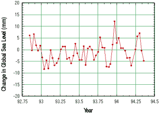
SLR contributes to the monitoring of sea level change in two ways. First, by supplying tracking data for orbit determination, SLR assures excellent radial orbital knowledge of altimeter satellites. Second, by improving knowledge of mm/yr-level secular changes in the height of coastal observing sites, SLR helps to resolve ambiguities in the tide gauge record. The proper treatment of tide gauge data for global sea level monitoring requires correction for solid Earth elevation changes of the gauges, which are of the same magnitude in Europe and the US as the sea level change itself. Global sea level change is shown deduced from 60 10-day cycles of TOPEX/Poseidon data (Nerem, 1994).
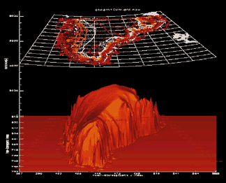
Measuring Changes in Ice and Land Topography
SLR measurements provide orbital knowledge supporting the mapping of continental ice fields using space-based radar altimeters. The topography (and its changes) of the Earth's ice sheets are mapped using satellite altimeters and precision orbits based on SLR and SLR-based force models (Zwally, et al., 1989).
Zwally, et al., Science, 246, 1587-1589, 1989.
Nerem, private communications, 1994.
