Satellite and Lunar Laser Ranging Contributions to Earth and Lunar Science
Satellite Laser Ranging (SLR)

In Satellite Laser Ranging, a short pulse of coherent light generated by a laser (Light Amplification by Stimulated Emission of Radiation) is transmitted in a narrow beam to illuminate corner cube retroreflectors on the satellite. The return signal, typically a few photons, is collected by a telescope and the time-of-flight is measured. Using information about the satellite’s orbit, the time-of-flight, and the speed of light, the location of the ranging station can be determined. Similar data acquired by another station, many kilometers distant from the first, or on a different continent, can be used to determine the distance between stations to precisions of centimeters or better. Repetitive measurements over months and years yield the change in distance, or the motion of the Earth’s crust.
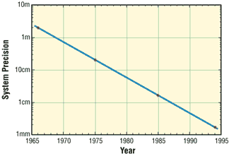
Laser ranging to a near-Earth satellite was initiated by NASA in 1964 with the launch of the Beacon-B satellite. Since that time, ranging precision, spurred by scientific requirements, has improved by a factor of a thousand from a few meters to a few millimeters. Similarly, the network of laser stations has grown from a few experimental sites to a global network of 43 stations in more than 30 countries. Most of these stations (33) are funded by organizations other than NASA.
During the past three decades, the global Satellite Laser Ranging (SLR) network has evolved into a powerful source of data for studies of the solid Earth and its ocean and atmospheric systems including:
- Detection and monitoring of tectonic plate motion, crustal deformation, Earth rotation, and polar motion;
- Modeling of the spatial and temporal variations of the Earth’s gravitational field;
- Determination of basin-scale ocean tides;
- Monitoring of millimeter-level variations in the location of the center of mass of the total Earth system (solid Earth-atmosphere-oceans);
- Establishment and maintenance of the International Terrestrial Reference System (ITRS); and
- Detection and monitoring of post-glacial rebound and subsidence.
In addition, SLR provides precise orbit determination for spaceborne radar altimeter missions mapping the ocean surface (which are used to model global ocean circulation), for mapping volumetric changes in continental ice masses, and for land topography. It provides a means for subnanosecond global time transfer, and a basis for special tests of the Theory of General Relativity.
SLR uses special, passive spacecraft in very stable orbits. A low area to mass ratio minimizes the effects of atmospheric drag and solar radiation pressure on the satellite’s orbit.
An example of such a satellite is the Laser Geodynamics Satellite (LAGEOS-1), which was launched by the United States in 1976 into a 6000 kilometer circular orbit with a near polar inclination. Lageos-I, and its sister satellite Lageos-II (built by the Agenzia Spaziale Italiana of Italy and launched in 1992 into a 6000 kilometer orbit, but with an inclination of 51 degrees) have a 60 centimeter spherical shape and weigh 411 kilograms. The exterior surface of both satellites is covered by 426 retroreflectors.
Other satellites for SLR include: Starlette (1000 km) and Stella (800 km) developed and launched by France: Etalon-I and -2 (19,000 km) developed and launched by the former USSR: and Ajisai (1500 km) developed and launched by Japan. To obtain data for precise orbit determination, retroreflectors are also mounted on the US/France Topex/Poseidon spacecraft, the European Space Agency Earth Remote Sensing satellites (ERS-1 and 2), and on a few of the United States Global Positioning System (GPS) satellites.
Fixed and mobile SLR systems have been used to acquire data for studies of crustal deformation and plate motion at scales from several hundred kilometers to several thousand kilometers: to monitor polar motion and Earth rotation: and to model the Earth’s gravity field.
Lunar Laser Ranging (LLR)
During three U.S. American Apollo missions (11, 14, and 15) and two unmanned Soviet missions (Luna 17 and Luna 21), retro-reflectors were deployed near the lunar landing sites between 1969 and 1973. The Lunar Laser Ranging (LLR) experiment has continuously provided range data for about 41 years, generating about 17000 normal points. The main benefit of this space geodetic technique is the determination of a host of parameters describing lunar ephemeris, lunar physics, the Moon's interior, various reference frames, Earth orientation parameters and the Earth-Moon dynamics. LLR has also become one of the strongest tools for testing Einstein's theory of general relativity in the solar system; no violations of general relativity have been found so far. However, the basis for all scientific analyses is more high quality data from a well-distributed global LLR network. More information is provided on the LLR page.
