
Quick Links
Belmont Report - SLR Contributions to Earth Science
SLR Contributions to Earth Science
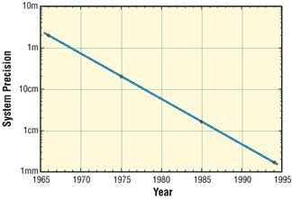
Laser ranging to a near-Earth satellite was initiated by NASA in 1964 with the launch of the Beacon-B satellite. Since that time, ranging precision, spurred by scientific requirements, has improved by a factor of a thousand from a few meters to a few millimeters. Similarly, the network of laser stations has grown from a few experimental sites to a global network of 43 stations in more than 30 countries. Most of these stations (33) are funded by organizations other than NASA.
During the past three decades, the global Satellite Laser Ranging (SLR) network has evolved into a powerful source of data for studies of the solid Earth and its ocean and atmospheric systems including:
- Detection and monitoring of tectonic plate motion, crustal deformation, Earth rotation, and polar motion;
- Modeling of the spatial and temporal variations of the Earth's gravitational field;
- Determination of basin-scale ocean tides;
- Monitoring of millimeter-level variations in the location of the center of mass of the total Earth system (solid Earth-atmosphere-oceans);
- Establishment and maintenance of the International Terrestrial Reference System (ITRS); and
- Detection and monitoring of post-glacial rebound and subsidence.
In addition, SLR provides precise orbit determination for spaceborne radar altimeter missions mapping the ocean surface (which are used to model global ocean circulation), for mapping volumetric changes in continental ice masses, and for land topography. It provides a means for subnanosecond global time transfer, and a basis for special tests of the Theory of General Relativity.
