
SWOT
Jump to: Mission Objectives, Mission Instrumentation, Mission Parameters, Additional Information
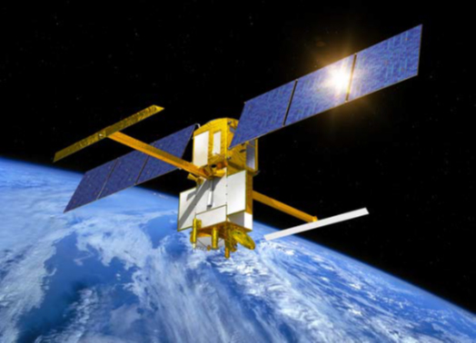
Mission Images:
 |
Mission Objectives:
The Surface Water / Ocean Topography (SWOT) mission is a partnership between two communities, physical oceanography and hydrology, to share high vertical accuracy and high spatial resolution topography data produced by the science payload, whose principal instrument is a Ka-band radar Interferometer. The SWOT Project was developed based upon a major international partnership between CNES and NASA.
Oceanography Objectives: The primary oceanographic objectives of the SWOT mission are to characterize the ocean mesoscale and submesoscale circulation at spatial resolutions of 15 km and larger (Previous altimeter constellations can only resolve the ocean circulation at resolutions larger than 200 km). Fundamental questions on the dynamics of ocean variability at scales shorter than 200 km, the mesoscale and submesocale processes, such as the formation, evolution, and dissipation of eddy variability (including narrow currents, fronts, and quasi-geostrophic turbulence) and its role in air-sea interaction, are to be addressed by the new observations, with direct implications in the following fields :
- Kinetic energy and tracer transports
- Climate change and ocean circulation
- Coastal tides and internal tides
Hydrology Objectives: The SWOT mission provides measurements of water storage changes in terrestrial surface water bodies and estimates of discharge in large (wider than 100 m) rivers, by directly measuring the surface water (lakes, reservoirs, rivers, and wetlands) component of the water cycle.
The primary hydrologic objectives of the SWOT mission are to characterize the spatial and temporal variations in surface waters, globally, and thus address the following hydrologic science issues:
- Terrestrial Water Cycle
- Floodplains and Wetlands
- Transboundary Rivers and Water Resources
SWOT was launched on Dec. 16th, 2022, with a planned lifetime of 3,5 years, the 6 first months of operations being dedicated to the calibration and validation of the system, using a 1-day repeat ground track at 857km altitude. It will then be transferred to a 890km altitude for nominal operations, with a repeat cycle of 21 days.
Role of SLR for the mission: Precision orbit determination is a fundamental requirement for achieving the goals of the SWOT mission. The SLR data play an important role in two ways (1) providing· strong tracking information to complement GNSS and DORIS, and (2) providing a unique and unambiguous verification of the absolute radial orbit accuracy.
Mission Parameters:
| Satellite Name: | SWOT |
| Sponsor: | NASA/CNES |
| Expected Life: | 3.5 years |
| Primary Applications: | Ocean altimetry and Hydrology (inland water storage) |
| COSPAR ID: | 2217301 |
| SIC Code: | 4381 |
| NORAD SSC Code: | 54754 |
| Launch Date: | December 16, 2022 |
| RRA Size: | |
| RRA Shape: | spherical surface |
| Reflectors: | 9 cubes |
| Size of Reflector: | ∼ 32mm diameter |
| Orbit: | slightly elliptical |
| Orbital period during CALVAL phase (first 6 months - 1-day repeat orbit): | 6131.25 s |
| Orbital period during SCIENCE phase (21-day repeat orbit): | 6173.62 s |
| Inclination: | 77.6 deg +/- 0.1 degrees |
| Altitude: | Min 850 km / Max 890 km |
| Eccentricity: | 0.00105 degrees |
Related Information:
- SWOT website
- Mission Support Request Form
- Information for SWOT Precise Orbit Determination (POD): “SWOT Characteristics for POD Processing”
- SWOT Body quaternions and solar panel angles (at IGN & CDDIS): documentation quaternions; documentation, solar panel angles
- SWOT Orbit and Attitude Representation (IDS Video on Youtube)
NASA and CNES Press Releases
- “Five Things to know about how SWOT will look at the World’s Water” (NASA, November 15, 2022)
- “SWOT observe des dizaines de milliers de monts sous-marins (SWOT observes tens of thousands of seamounts)” (CNES, July 15, 2024)
- ”International SWOT Satellite Spots Planet-Rumbling Greenland Tsunami” (NASA, October 31, 2024)
- “Next-generation Water Satellite Maps Seafloor from Space” (NASA, March 19, 2025)
Publications:
- Biancamaria S., Lettenmaier D.P., Pavelsky T.M. (2016). "The SWOT Mission and its capabilities for Land Hydrology", Surveys in Geophysics, 37(2), 307-337, doi: 10.1007/s10712-015-9346-y.
- Fu L.‐L., Pavelsky T., Crétaux J.‐F., Morrow R., et al. (2024). “The Surface Water and Ocean Topography Mission: A breakthrough in radar remote sensing of the ocean and land surface water”. Geophys. Res. Lett, 51, e2023GL107652, doi:10.1029/2023GL107652.
- Getirana A., Kumar S., Bates P. et al. (2024). “The SWOT mission will reshape our understanding of the global terrestrial water cycle”, Nature Water, 2, 1139-1142, doi: 10.1038/s44221-024-00352-0.
- Hart-Davis M. G., Andersen O. B., Ray R. D. et al. (2024). “Tides in complex coastal regions: Early case studies from wide-swath SWOT measurements”, Geophys. Res. Lett., 51, e2024GL109983, doi:10.1029/2024GL109983.
- Houry S., Moyard J., Mercier F., Couhert A. (2023). “SWOT news”, Presentation on SWOT POD at the IDS Analysis Working Group Meeting, April 18, 2023. (URL: https://ids-doris.org/images/documents/report/AWG202304/IDSAWG202304-Couhert-Swot.pdf)
- Morrow R., Fu L.-L., Ardhuin F. et al. (2019). "Global Observations of Fine-Scale Ocean Surface Topography With the Surface Water and Ocean Topography (SWOT) Mission", Frontiers in Marine Sci., 6(232), doi: 10.3389/fmars.2019.00232.
- Surface Water and Ocean Topography Mission (SWOT) Project Science Requirements Document, Rev. B., edited by Shailen Desai, JPL D-61923, Jet Propulsion Laboratory, Pasadena, California, January 24, 2018: URL: https://swot.jpl.nasa.gov/system/documents/files/2176_2176_D-61923_SRD_Rev_B_20181113.pdf.
