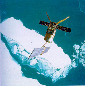
ERS-2
Jump to: Mission Objectives, Mission Instrumentation, Mission Parameters, Additional Information
Mission Photos:

Courtesy of ESA/ESRIN
Mission Objectives:
The European Remote Sensing satellite, ERS-2, is the follow-on mission to ERS-1 and was launched in April 1995. ERS-2 will over the years, 1995-98, continue the work begun by ERS-1; however the ERS-2 mission will have to deal with an even more demanding range of tasks. ERS-2 is equipped with additional new instruments that will measure the ozone content of the atmosphere and monitor changes in vegetation cover more effectively. What is more, the European Space Agency (ESA) exercised the option of operating the two craft "in tandem" for a period of time which opened up completely new perspectives for many research teams and high-tech firms.
After 16 years spent gathering a wealth of data that has revolutionised our understanding of Earth, ERS-2 satellite was retired. The science mission ended on July 4, 2011 (orbit # 84719). The lowering of the orbit began shortly after retirement and will last until early September, when a number of long manoeuvres will exhaust the fuel and finally the batteries and communications will be disconnected. For more on the ERS-2 retirement, mission, successes, can be found on the ESA website.
Envisat-1 is the follow-on mission to ERS-2.
Mission Instrumentation:
ERS-2 has the following instrumentation onboard:
- Synthetic aperture radar
- Wind scaterrometer
- Radar altimeter
- Along-track scanning radiometer
- Microwave sounder
- Global Ozone Monitoring Experiment (GOME)
- Precise Range and Range-Rate Equipment (PRARE)
- Retroreflector array
Mission Parameters:
| Sponsor: | European Space Agency |
| Expected Life: | 3-4 years |
| Primary Applications: | remote sensing and environmental monitoring |
| Primary SLR Applications: | calibration of satellite altimeter |
| COSPAR ID: | 9502101 |
| SIC Code: | 6178 |
| Satellite Catalog (NORAD) Number: | 23560 |
| Launch Date: | April 21, 1995 |
| RRA Diameter: | 20 cm |
| RRA Shape: | hemispherical |
| Reflectors: | 9 corner cube |
| Orbit: | circular |
| Inclination: | 98.5 degrees |
| Eccentricity: | 0.001 |
| Perigee: | 785 km |
| Period: | 100 minutes |
| Weight: | 2516 kg |
Additional Information:
Web sites:
- ESA ERS home page
- EURIMAGE ERS home page
- JPL ERS home page
- ESA/ESOC ERS POD home page
- ERS-2 maneuver history (ESA)
Publications:
- Andersen, P.H., Aksnes, K., Skonnord, H., "Precise ERS-2 orbit determination using SLR, PRARE and RA observations", Journ. of Geod, Vol. 72, No. 7/8, pp. 421-429, 1998.
- Massmann, F.H., Flechtner, F., Raimondo, J.C., and Reigber, Ch., "Impact of PRARE on ERS-2 POD", Advances in Space Research, Vol. 19, No.11, 1645-1648, 1997.
- Reading, C., Stevenson, I., and de Villiers, N., "ERS-2 and Beyond", Magazine-ESA Bulletin, No. 65, pp. 95-99, 1991.
- Ries, J.C., Bordi, J.J., and Urban, T.J., "Precise Orbits for ERS-2 Using Laser Ranging and PRARE Tracking", CSR-TM-99-03, Center for Space Research, The University of Texas at Austin, May 1999.
- Visser, P.N.A.M., Scharoo, R, and Ambrosius, B.A.C., "Application of ERS-2 PRARE data for orbit determination and gravity field and station coordinate estimation", Adv. Space Res., 30, 2, pp. 249-254, 2002.


