Quick Links
INTERNATIONAL LASER RANGING SERVICE (ILRS)
M. R. Pearlman 1, C. E. Noll 2 and W. Gurtner 3
1 Harvard-Smithsonian Center for Astrophysics (CfA),
Cambridge, MA USA 02138, USA
2 NASA Goddard Space Flight Center, Greenbelt, MD 20771, USA
3 Astronomical Institute, University of Berne, CH-3012 Berne,
Switzerland
CONTRIBUTIONS OF THE ILRS
The ILRS collects, merges, analyzes, archives and distributes Satellite Laser Ranging (SLR) and Lunar Laser Ranging (LLR) observation data sets of sufficient accuracy to satisfy the objectives of a wide range of scientific, engineering, and operational applications and experimentation. The basic observable is the precise time-of-flight of an ultrashort laser pulse to and from a satellite, corrected for atmospheric delays and spacecraft center-of-mass. These data sets are used by the ILRS to generate fundamental data products, including: accurate satellite ephemerides, Earth orientation parameters, three-dimensional coordinates and velocities of the ILRS tracking stations; time-varying geocenter coordinates, static and time-varying coefficients of the Earth's gravity field, fundamental physical constants, lunar ephemerides and librations, and lunar orientation parameters
ORGANIZATION AND ROLE OF THE ILRS
The ILRS Tracking Stations range to a constellation of artificial satellites and the Moon with state-of-the-art laser ranging systems and transmit their data on an hourly basis to an Operations or Data Center. Stations are expected to meet ILRS data accuracy, quantity, and timeliness requirements, and their data must be regularly and continuously analyzed by at least one Analysis or mission-specific Associate Analysis Center. Each Tracking Station is typically associated with one of the three regional subnetworks: National Aeronautics and Space Administration (NASA), EUROpean LASer Network (EUROLAS), or the Western Pacific Laser Tracking Network (WPLTN).
Operations Centers collect and merge the data from the tracking sites, provide initial quality checks, reformat and compress the data if necessary, maintain a local archive of the tracking data, and relay the data to a Data Center. Operational Centers may also provide the Tracking Stations with sustaining engineering, communications links, and other technical support. Tracking Stations may perform part or all of the tasks of an Operational Center themselves.
Global Data Centers are the primary interfaces between the Tracking Stations and the Analysis Centers and outside users. They receive and archive ranging data and supporting information from the Operations and Regional Data Centers, and provide these data on-line to the Analysis Centers. They also receive and archive ILRS scientific data products from the Analysis Centers and provide these products on-line to users. Regional Data Centers reduce traffic on electronic networks and provide a local data archive.
Analysis Centers receive and process tracking data to produce ILRS
products. They are committed to produce the products on a routine
basis for delivery to the Global Data Centers and the IERS using
designated standards. Full Analysis Centers routinely process
the global LAGEOS-1 and LAGEOS-2 data and provide Earth orientation
parameters on a weekly or sub-weekly basis. They also produce
other products such as station coordinates and velocities and
geocenter coordinates on a schedule consistent with IERS requirements
and provide a second level of data quality assurance in the network.
Associate Analysis Centers produce specialized products, such
as time-varying gravity field measurements, fundamental constants,
satellite predictions, precision orbits for special-purpose satellites,
regional geodetic measurements, and data products of a mission-specific
nature. Associate Analysis Centers are also encouraged to perform
quality control functions through the direct comparison of Analysis
Center products and the creation of "combined" solutions
using data from other space geodetic techniques. Lunar Analysis
Centers produce LLR products such as lunar ephemeris, lunar libration,
and Earth rotation (UT0 - UT1). In the field of relativity, LLR
is used for the verification of the equivalence principle, estimation
of geodetic precession, and examination of the relative change
in G.
CENTRAL BUREAU
The ILRS Central Bureau (CB) is responsible for the daily coordination and management of ILRS activities. It facilitates communications and information transfer and promotes compliance with ILRS network standards. The CB monitors network operations and quality assurance of the data, maintains all ILRS documentation and databases, and organizes meetings and workshops. In order to strengthen the ILRS interface with the scientific community, a Science Coordinator and an Analysis Specialist within the CB take a proactive role to enhance dialogue, to promote SLR goals and capabilities, and to educate and advise the ILRS entities on current and future science requirements related to SLR. The Science Coordinator leads efforts to ensure that ILRS data products meet the needs of the scientific community and there is easy online access to all published material (via Abstracts) relevant to SLR science and technology objectives.
The CB has been actively providing new facilities to expedite communication and performance review, and adding to the technical and scientific database. The information available via the ILRS Web Site has grown enormously since its inception, and many new links to related organizations and sites have been established. The site provides details and photographic material on the ILRS, the satellites and campaigns, individual SLR station characteristics, a scientific and technical bibliography on SLR and its applications, current activities of the Governing Board, Working Groups, and Central Bureau, meeting minutes and reports (including annual reports), tracking plans, and much more. An enhanced search capability has recently been added to the website.
The Central Bureau maintains the web site as the primary vehicle for the distribution of information within the ILRS community. The site, which can be accessed at http://ilrs.gsfc.nasa.gov, includes the following major topic titles: About the ILRS, What's New, Working Groups, Satellite Missions, Global Network, Data and Products, Science and Analysis, Engineering and Technology, Publications, Contact ILRS, Links, Site Map, and Search. Mirrored sites for the ILRS web site are available at the Communications Research Laboratory (CRL) in Tokyo and the European Data Center (EDC) in Munich. The site also includes SLR related bibliographies, Earth science links, historical information, collocation histories, and mail exploders. An on-line brochure provides charts for SLR presentations. A hard copy library of early documentation has been assembled and is listed in the on-line bibliography. An ILRS Reference Card is available to provide easy online access to much of this material and to targeted email exploders.
GOVERNING BOARD AND WORKING GROUPS
The Governing Board (GB) is responsible for the general direction of the service. It defines official ILRS policy and products, determines satellite-tracking priorities, develops standards and procedures, and interacts with other services and organizations. There are sixteen members of the Governing Board (GB) - three are ex-officio, seven are appointed, and six are elected by their peer groups (see Table 1). A new Board was installed in November 2002 at the 13th International Workshop in Washington D.C.
Table 1. ILRS Governing Board (as of May 2003)
| Hermann Drewes | Ex-Officio, CSTG President | Germany |
| Michael Pearlman | Ex-Officio, Director ILRS Central Bureau | USA |
| Carey Noll | Ex-Officio, Secretary, ILRS Central Bureau | USA |
| Werner Gurtner | Appointed, EUROLAS , Governing Board Chair | Switzerland |
| Giuseppe Bianco | Appointed, EUROLAS | Italy |
| David Carter | Appointed, NASA, Missions Working Group Coordinator. | USA |
| Jan McGarry | Appointed, NASA, Data Formats & Procedures WG Deputy Coordinator | USA |
| Ben Greene | Appointed, WPLTN | Australia |
| Hiroo Kunimori | Appointed, WPLTN, Missions WG Deputy Coordinator | Japan |
| Bob Schutz | Appointed, IERS Representative to ILRS | USA |
| Graham Appleby | Elected, Analysis Rep., Signal Processing WG Coordinator | UK |
| Ron Noomen | Elected, Analysis Rep. , Analysis WG Coordinator | Netherlands |
| Wolfgang Seemueller | Elected, Data Centers Rep. , Data Formats & Procedures WG Coordinator | Germany |
| Peter Shelus | Elected, Lunar Rep., Analysis WG Deputy Coordinator | USA |
| Georg Kirchner | Elected, At-Large, Networks and Engineering WG Coordinator | Austria |
| Ulrich Schreiber | Elected, At-Large, Networks and Engineering WG Deputy Coordinator | Germany |
Within the GB, permanent (Standing) or temporary (Ad-Hoc) Working Groups (WG's) carry out policy formulation for the ILRS. At its creation, the ILRS established four Standing WG's: (1) Missions, (2) Data Formats and Procedures, (3) Networks and Engineering, and (4) Analysis. In 1999, an Ad-Hoc Signal Processing WG was organized to provide improved satellite range correction models to the analysts. The Working Groups are intended to provide the expertise necessary to make technical decisions, to plan programmatic courses of action, and are responsible for reviewing and approving the content of technical and scientific databases maintained by the Central Bureau. All GB members serve on at least one of the four Standing Working Groups, led by a Coordinator and Deputy Coordinator (see Table 1).
The working groups have attracted talented people from the general ILRS membership who have contributed greatly to the success of these efforts. The Missions WG has formalized and standardized the mission documentation required to obtain ILRS approval for new missions and campaigns. They continue to work with new missions and campaign sponsors to develop and finalize tracking plans and to establish recommended tracking priorities. The Data Formats and Procedures WG has been reviewing existing formats and procedures, rectifying anomalies, providing standardized documentation through the web site, and setting up study subgroups and teams to deal with more complicated or interdisciplinary issues. The Networks and Engineering WG has (1) developed the new ILRS Site and System Information Form, which is being distributed to the stations to keep the engineering database current, (2) provided a new online satellite-link analysis capability for system design and performance evaluation, and (3) initiated the development of the ILRS technology database. The Analysis WG has been working with the ILRS Analysis Centers to develop a unified set of analysis products presented in the internationally accepted SINEX format. Three associated pilot programs are underway to assess differences among analysis products from the different Analysis and Associate Analysis centers. The Signal Processing Ad-Hoc WG is working on improved center-of-mass corrections and signal processing techniques for SLR satellites.
ILRS NETWORK
The ILRS Network as of May 2003 is shown in Figure 1. Traditionally the network has been strong in the US, Europe, and Australia. Through international partnerships, the global distribution of SLR stations is now improving, especially in the Southern Hemisphere. NASA, CNES and the University of French Polynesia have established SLR operations on the island of Tahiti with MOBLAS-8. In cooperation with the South African Foundation for Research Development (FDR), NASA has relocated MOBLAS-6 to Hartebeesthoek (which already has VLBI, GPS, and DORIS facilities) to create the first permanent Fundamental Station on the African continent. MOBLAS-5, long established by NASA and AUSLIG at Yarragadee, Australia, continues to operate with exemplary performance. Operations at the new Australian station on Mt. Stromlo, which replaced the older Orroral site near Canberra, were going extremely well until a catastrophic forest fire destroyed the site and much of the surrounding area. Reconstruction is now being planned.
The NASA TLRS-3 system at Universidad de San Agustin in Arequipa, Peru, has carried the total SLR tracking load for South America in recent years. BKG (Germany) has now established a new site at Concepción, Chile with its newly developed multi-technique Totally Integrated Geodetic Observatory (TIGO). The TIGO, with SLR, VLBI, GPS and absolute gravimetry technique, now provides the first Fundamental Station in South America. A joint Chinese-Argentine SLR station at the San Juan Observatory in western Argentina is being planned with SLR equipment furnished by the Beijing Astronomical Observatory.
The Peoples' Republic of China has made substantial investment in SLR stations and technology over the past two years. The SLR station in Kunming was recently re-established, bringing the total number of Chinese permanent sites to five (Shanghai, Changchun, Wuhan, Beijing, and Kunming). The data quality and quantity from the permanent Chinese stations continue to improve, most notably at Changchun. The Wuhan SLR station has been recently moved to a site outside the city with significantly better atmospheric seeing conditions. The Shanghai SLR station is slated for relocation this year for similar reasons. A Chinese mobile SLR station has occupied sites in Lhasa and Urumuqi, as part of a national geodetic program. A new Russian SLR station started operations near Moscow in 1999, and permission is being requested from the Russian government to integrate it into international SLR operations.
In Japan, an upgraded SLR station at the Communications Research Laboratory (CRL) in Tokyo is now operational. The four Keystone sites at Kashima, Tateyama, Koganei and Miura have been closed, but the new Global and High Accuracy Trajectory determination System (GUTS) SLR system is being developed by NASDA for deployment at Tanegashima.
During the past four years, there has also been considerable activity in Europe. The new state-of-the-art Matera Laser Ranging Observatory (MLRO) with both SLR and lunar ranging capability is now operational with very impressive performance. The Zimmerwald system has been completely rebuilt, with submission of operational data starting again in early 2000 and routine dual-frequency data starting during the past year. The SLR station in Potsdam has been totally upgraded. The French Transportable Laser Ranging System (FTLRS) was operated at the Ajaccio, Corsica in support of Jason and other altimeter satellites, and is now operating at a site near Crete.
Sites in the United States have been relatively stable over the
past several years, with efforts continuing to improve overall
performance or reducing the cost of SLR operations. The Maui site
has been upgraded. A new LLR station is being built in Apache
Point, Washington. Work continues on the SLR2000 prototype with
field test planned for fall 2003.
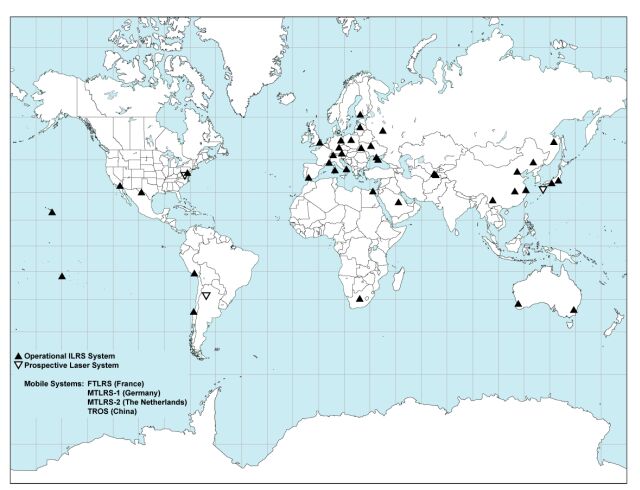
Figure 1. ILRS Network (as of May 2003)
ILRS TRACKING PRIORITIES AND CAMPAIGNS
The ILRS is currently tracking 25 artificial satellites including passive geodetic (geodynamics) satellites, Earth remote sensing satellites, navigation satellites, and engineering missions (see Table 2). The stations with lunar capability are also tracking the lunar reflectors. In response to tandem missions (e.g. GRACE-A/-B) and general overlapping schedules, stations have begun tracking satellites with interleaving procedures. The network continues to support three GLONASS satellites selected by the International GLONASS Pilot Project (IGLOS), a project within the International GPS Service (IGS).
The ILRS assigns satellite priorities in an attempt to maximize data yield on the full satellite complex while at the same time placing greatest emphasis on the most immediate data needs. Priorities provide guidelines for the network stations, but stations may occasionally deviate from the priorities to support regional activities or national initiatives and to expand tracking coverage in regions with multiple stations. Tracking priorities are set by the Governing Board, based on application to the Central Bureau and recommendation of the Missions Working Group.
Since several remote sensing missions have suffered failures in their active tracking systems or have required in-flight recalibration, the ILRS has encouraged new missions with high precision orbit requirements to include retroreflectors as a fail-safe backup tracking system, to improve or strengthen overall orbit precision, and to provide important intercomparison and calibration data with onboard microwave navigation systems.
UPCOMING MISSIONS
At one time, the main task of the international SLR Network was the tracking of dedicated geodetic satellites (LAGEOS, Starlette, etc.). Although we have had requests to revive tracking on older satellites already in orbit (e.g., Beacon-C) to further refine the gravity field with improved accuracy laser data, new requests for tracking are now coming mainly for active satellites. The tracking approval process begins with the submission of a Missions Support Request Form, which is accessible through the ILRS web site. The form provides the ILRS with the following information: a description of the mission objectives; mission requirements; responsible individuals, organizations, and contact information; timeline; satellite subsystems; and details of the retroreflector array and its placement on the satellite. This form also outlines the early stages of intensive support that may be required during the initial orbital acquisition and stabilization and spacecraft checkout phases. A list of upcoming space missions that have requested ILRS tracking support is summarized in Table 3 along with their sponsors, intended application, and projected launch dates.
Table 2. ILRS Tracking Priorities (as of May 2003)
| Satellite Priorities | |||||
| Priority | Mission | Sponsor | Altitude(km) | Inclination(degrees) | Comments |
| 1 | GRACE-A, -B | GFZ/JPL | 485-500 | 89 | tandem mission |
| 2 | CHAMP | GFZ | 429-474 | 87.27 | |
| 3 | GFO-1 | US Navy | 790 | 108.0 | altimetry/no other tracking technique |
| 4 | ENVISAT | ESA | 796 | 98.6 | tandem with ERS-2 tracking to commence 40 days after launch |
| 5 | ERS-2 | ESA | 800 | 98.6 | tandem with ENVISAT |
| 6 | Jason | NASA/CNES | 1,350 | 66.0 | tandem with Topex* |
| 7 | TOPEX/Poseidon | NASA/CNES | 1,350 | 66.0 | tandem with Jason* |
| 8 | Starlette | CNES | 815-1,100 | 49.8 | |
| 9 | Stella | CNES | 815 | 98.6 | |
| 10 | METEOR-3M | IPIE | 1000 | 99.64 | |
| 11 | Beacon-C | NASA | 950-1300 | 41 | upgraded from campaign to ongoing mission (Jan-02) |
| 12 | Ajisai | NASDA | 1,485 | 50 | |
| 13 | LAGEOS-2 | ASI/NASA | 5625 | 52.6 | |
| 14 | LAGEOS-1 | NASA | 5850 | 109.8 | |
| 15 | Etalon-1 | Russian Federation | 19,100 | 65.3 | campaign extended indefinitely |
| 16 | Etalon-2 | Russian Federation | 19,100 | 65.2 | campaign extended indefinitely |
| 17 | GLONASS-89 | Russian Federation | 19,100 | 65 | replaced GLONASS-86 as of20-Mar-03 |
| 18 | GLONASS-87 | Russian Federation | 19,100 | 65 | replaced GLONASS-88 as of20-Feb-02 |
| 19 | GLONASS-84 | Russian Federation | 19,100 | 65 | replaced GLONASS-79 as of22-Feb-01 |
| 20 | GPS-35 | US DoD | 20,100 | 54.2 | |
| 21 | GPS-36 | US DoD | 20,100 | 55.0 | |
| Lunar Priorities | |||||
| Priority | Retroreflector Array | Sponsor | Altitude(km) | ||
| 1 | Apollo 15 | NASA | 356,400 | ||
| 2 | Apollo 11 | NASA | 356,400 | ||
| 3 | Apollo 14 | NASA | 356,400 | ||
| 4 | Luna 21 | Russian Federation | 356,400 | ||
| 5 | Luna 17 | Russian Federation | 356,400 | ||
Once tracking support is approved by the Governing Board, the Central Bureau works with the new missions to develop a Mission Support Plan detailing the level of tracking, the schedule, the points of contact, and the channels of communication. New missions normally receive very high priority during the acquisition and checkout phases and are then placed at a routine priority based on the satellite category and orbital parameters. After launch, New Mission Reports with network tracking statistics and operational comments are issued weekly. The Central Bureau monitors progress to determine if adequate support is being provided. New mission sponsors (users) are requested to report at the ILRS Plenary meetings on the status of ongoing campaigns, including the responsiveness of the ILRS to their needs and on progress towards achieving the desired science or engineering results.
Table 3. Upcoming Missions (as of May 2003)
| Mission Name | Support Requester | Mission Type | Planned Launch Date | Mission Duration | Altitude (km) | Inclination (deg) | Mission Request Form Received |
| ICESat (GLAS)? | NASA USA |
Ice Balance, Oceans |
January 2003 | 3-5 years | 600 | 94 | yes |
| GP-B | NASA-JPL USA |
Relativity | October 2003 | 1-2 years | 400 | 90 | yes |
| NPOESS | NASA, NOAA, DoD USA |
Atmosphere | April 2013 | 7 years | 833 | 98.7 | yes |
Note: †As of May 2003, ICESat tracking approved for only selected ILRS stations
MEETINGS AND REPORTS
The ILRS organizes semiannual meetings of the Governing Board and General Assembly, which is open to all ILRS Associates and Correspondents. The spring ILRS General Assemblies are generally held in conjunction with the EGS Symposium in Nice, France, and focus more on mission support. The fall meetings are more oriented toward SLR practitioners. A summary of recent ILRS meetings is shown in Table 4. Detailed reports from past meetings can be found on the ILRS web site.
Table 4. Recent ILRS Meetings (as of May 2003)
| Timeframe | Location | Meeting |
| September 1999 | The Hague, Netherlands | 3rd ILRS General Assembly |
| January 2000 | Frankfurt, Germany | Analysis Working Group |
| April 2000 | Nice, France | 4th ILRS General Assembly |
| May 2000 | Delft, Netherlands | Analysis Working Group |
| November 2000 | Matera, Italy | 12th International Workshop on Laser Ranging |
| 5th ILRS General Assembly | ||
| March 2001 | Nice, France | 6th ILRS General Assembly and WG Meetings |
| Analysis Working Group | ||
| September 2001 | Toulouse, France | 7th ILRS General Assembly (canceled) |
| April 2002 | Nice, France | 7th ILRS General Assembly and WG Meetings |
| Analysis Working Group | ||
| October 2002 | Washington, D.C., USA | 13th International Workshop on Laser Ranging |
| 8th ILRS General Assembly and WG Meetings | ||
| Analysis Working Group | ||
| April 2003 | Nice, France | 9th ILRS General Assembly and WG Meetings |
| Analysis Working Group |
The ILRS Annual Reports are published yearly and summarize activities within the service each year. They are available as hard copy from the CB or online at the ILRS Web Site.
ILRS Analysis Center reports and inputs are used by the Central Bureau for weekly review of station performance and to provide feedback to the stations when necessary. Special weekly reports on on-going campaigns are issued by email. The CB also generates Quarterly Performance Report Cards and posts them on the ILRS web site. The Report Cards evaluate data quantity, data quality, and operational compliance for each tracking station relative to ILRS minimum performance standards. A catalogue of diagnostic methods, for use along the entire data chain starting with data collection at the stations, has emerged from this process and will be made available on the ILRS web site. The evaluation process has been helpful in comparing results from different Analysis and Associate Analysis Centers, a role soon to be assumed by the Analysis Working Group.
